Location
Aras Residences location: Taman OUG, 16 minutes on foot to Sri Petaling LRT
Jalan Hujan Rintik, inside the WCity OUG masterplan in Taman OUG, Kuala Lumpur, just north of the KESAS Highway. The tables below list every station, shop, school and hospital on the developer's map, with the OpenStreetMap walking route.
Address and where the site sits
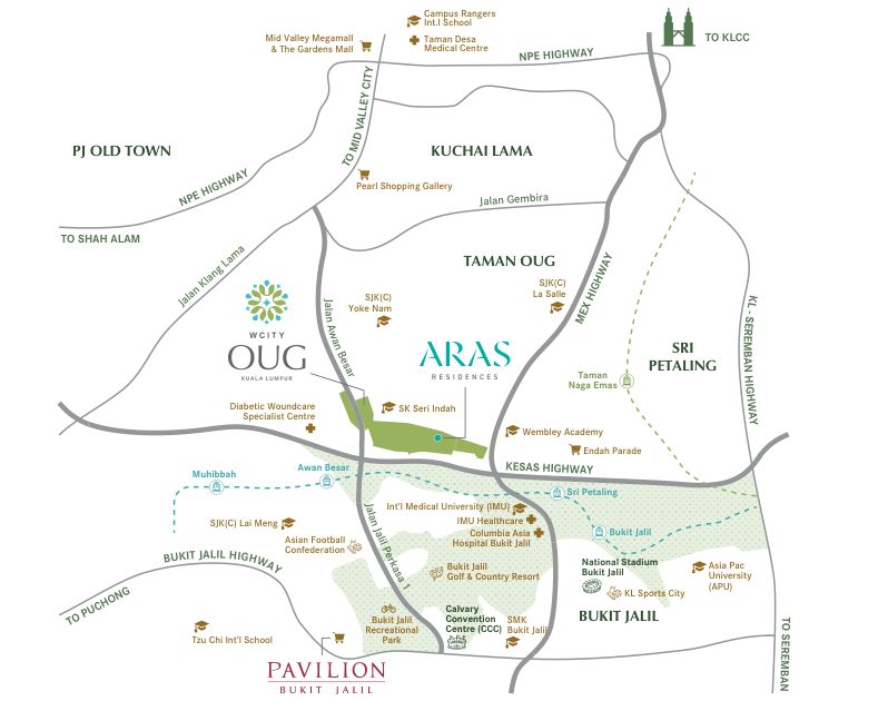
The towers rise on Jalan Hujan Rintik inside WCity OUG, a WCT masterplan in Taman Overseas Union (Taman OUG), off Old Klang Road. On the developer's map the site lies east of SK Seri Indah, between Jalan Awan Besar and the MEX Highway, with the KESAS Highway along its southern side.
- Address
- Jalan Hujan Rintik, WCity OUG, Taman Overseas Union, 58200 Kuala Lumpur
- Masterplan
- WCity OUG by WCT: a commercial block, a central park and a future development zone, beside The Maple Residences and Waltz Residences
- Site
- 3.35 acres, freehold, Commercial (HDA) title
- Stage
- Piling stage in March 2026; completion targeted for Q4 2029
- Viewings
- WCT Property Gallery, Lot PT 15210, Jalan Awan Besar. Weekdays 9.30am to 6.30pm, weekends 10am to 6pm
For example, a buyer coming for a viewing goes to the WCT Property Gallery on Jalan Awan Besar. The tower site on Jalan Hujan Rintik is a construction site until completion.
Nearest stations, and which one you can walk to
Five stations appear on the developer's map. Sri Petaling LRT is the only one that is a realistic daily walk: 1.1 km to exit A, about 16 minutes, along Jalan Hujan Rintik, Jalan 2/149 and Jalan Barat.
| Station | Line · code | Developer's distance | On foot (OSM route) |
|---|---|---|---|
| Sri Petaling LRT (exit A) | Sri Petaling Line · SP18 | 1.6 km | 1.1 km · 16 min |
| Bukit Jalil LRT | Sri Petaling Line · SP17 | 2.3 km | 2.1 km · 28 min |
| Awan Besar LRT | Sri Petaling Line · SP19 | 3.0 km | 3.1 km · 41 min |
| Muhibbah LRT (exit A) | Sri Petaling Line · SP20 | 3.6 km | 4.0 km · 54 min |
| Taman Naga Emas MRT (exit A) | Putrajaya Line · PY28 | 4.0 km | 3.6 km · 48 min |
Taman Naga Emas is the only MRT station on the map. At 48 minutes on foot it works as a short drive or ride, not a walk. Muhibbah and Awan Besar sit west of the site, 41 to 54 minutes away on foot.
Leave home on foot at 7.30am, for example, and you reach Sri Petaling exit A at about 7.46am. Walking routes follow the streets on OpenStreetMap today; WCity OUG's own roads and park paths are still under construction, so routes will change when they open.
How many stops to the city
Two lines serve the area. The Sri Petaling Line runs north through Bandar Tasik Selatan and Chan Sow Lin to Masjid Jamek. The Putrajaya Line runs from Taman Naga Emas through TRX, Conlay and Persiaran KLCC MRT to Hospital Kuala Lumpur.
| Destination | Board at | Stops |
|---|---|---|
| Bukit Jalil | Sri Petaling LRT | 1 |
| Sungai Besi (change for the Putrajaya Line) | Sri Petaling LRT | 2 |
| Bandar Tasik Selatan (KTM Komuter and KLIA Transit) | Sri Petaling LRT | 3 |
| Chan Sow Lin (change for the Putrajaya Line) | Sri Petaling LRT | 7 |
| Masjid Jamek (change for KL City Centre) | Sri Petaling LRT | 11 |
| Titiwangsa | Sri Petaling LRT | 15 |
| Kuchai | Taman Naga Emas MRT | 1 |
| Chan Sow Lin | Taman Naga Emas MRT | 2 |
| Tun Razak Exchange (TRX) | Taman Naga Emas MRT | 3 |
| Conlay | Taman Naga Emas MRT | 4 |
| Persiaran KLCC MRT | Taman Naga Emas MRT | 5 |
| Hospital Kuala Lumpur | Taman Naga Emas MRT | 8 |
| Titiwangsa | Taman Naga Emas MRT | 9 |
A TRX office worker, for example, can walk 16 minutes to Sri Petaling, ride 2 stops to Sungai Besi and change to the Putrajaya Line for 4 more stops to TRX: 6 stops in all. The other way is 7 stops to Chan Sow Lin, then 1 stop on the Putrajaya Line.
Shops and daily needs
The Food Merchant supermarket is already open beside the WCity OUG sales gallery, 2.7 km and a 37-minute walk away. WCity OUG's own commercial block is still planned. Beyond the masterplan, the nearest mall on the developer's map is Endah Parade, 2.7 km away and a 31-minute walk.
| Place | Developer's distance | On foot (OSM route) |
|---|---|---|
| The Food Merchant (WCity OUG) | — | 2.7 km · 37 min |
| Endah Parade | 2.7 km | 2.3 km · 31 min |
| Pearl Shopping Gallery | 4.2 km | 3.3 km · 45 min |
| Pavilion Bukit Jalil | 4.7 km | 4.4 km · 60 min |
| Mid Valley Megamall and The Gardens Mall | 9.5 km | Drive, about 9 km via Old Klang Road |
A weekly grocery run to Endah Parade, for example, is 31 minutes each way on foot, so a car or e-hailing ride is the practical choice. Pavilion Bukit Jalil is 4.4 km on foot, so it is usually a drive.
Schools, international schools and universities
Three Chinese-medium schools, one national school and one university (IMU) sit within 4 km on the developer's map. APU is 5.4 km away, and the two international schools on the map are 5.9 km and 6.9 km away.
| School | Type | Developer's distance | On foot (OSM route) |
|---|---|---|---|
| SK Seri Indah | National school | 1.0 km | 1.7 km · 23 min |
| Wembley Academy | Private school (Cambridge curriculum) | 1.7 km | Not on the street map |
| SJK (C) Yoke Nam | Chinese-medium school | 1.8 km | 2.2 km · 30 min |
| International Medical University (IMU) | University | 2.1 km | 1.2 km · 17 min |
| SJK (C) La Salle | Chinese-medium school | 2.8 km | 1.9 km · 25 min |
| SJK (C) Lai Meng | Chinese-medium school | 3.8 km | 3.9 km · 53 min |
| Asia Pacific University (APU) | University | 5.4 km | 4.8 km · 65 min |
| Tzu Chi International School | International school | 5.9 km | Drive (6.8 km on foot) |
| Campus Rangers International School | International school | 6.9 km | Drive |
SK Seri Indah is 1.0 km on the developer's map but 1.7 km on foot, because today's route loops out along Jalan Hujan Rintik and through Taman OUG. A parent choosing a Chinese-medium school, for example, has Yoke Nam at 1.8 km, La Salle at 2.8 km and Lai Meng at 3.8 km. An IMU student walks to campus in about 17 minutes (1.2 km).
Hospitals and clinics
Two medical centres are 2.0 km away on the developer's map, both on the Bukit Jalil side of the KESAS Highway.
| Hospital | Developer's distance | On foot (OSM route) |
|---|---|---|
| Columbia Asia Hospital Bukit Jalil | 2.0 km | 1.4 km · 19 min |
| IMU Healthcare | 2.0 km | — |
| KMI Taman Desa Medical Centre | 6.0 km | Drive |
A resident who works at Columbia Asia Hospital Bukit Jalil can walk there in about 19 minutes (1.4 km), for example, instead of driving. KMI Taman Desa Medical Centre, at 6.0 km, is a drive.
Parks and sport
Inside the masterplan, a 200m linear park is planned to link to WCity OUG's central park. South of the KESAS Highway lies the Bukit Jalil sports belt.
| Place | Developer's distance | On foot (OSM route) |
|---|---|---|
| Bukit Jalil National Stadium | 2.9 km | 2.1 km · 29 min |
| Bukit Jalil Recreational Park | 2.9 km | 3.8 km · 52 min |
| KL Sports City | 3.1 km | — |
| Bukit Jalil Golf & Country Resort | 3.5 km | Drive |
| Asian Football Confederation | 3.6 km | 3.4 km · 46 min |
On a concert or match night at the National Stadium, for example, the walk takes about 29 minutes (2.1 km) and avoids stadium parking.
Highways and drive distances
The developer lists five major highways: MRR2/KESAS, the Maju Expressway (MEX), the Bukit Jalil Highway, the KL-Seremban Highway and the NPE. The SUKE Highway also appears on the developer's area map.
| Destination | Route | Distance |
|---|---|---|
| The Gardens Mall and Mid Valley | Old Klang Road | About 9 km |
| IOI Mall Puchong | KESAS Highway | About 12 km |
| Sunway Pyramid and Sunway Medical | KESAS Highway | About 12 km |
| KL City Centre | KESAS – Sungai Besi Highway | About 14 km |
| KLIA (airport) | North-South Expressway | About 50 km |
Drive times depend on traffic. For example, to reach KLIA without a car, ride the LRT 3 stops from Sri Petaling to Bandar Tasik Selatan, where KLIA Transit stops.
The developer's location map
The map below is the developer's own. It shows the rail lines, highways, schools and malls named on this page.
Who this location suits, and who it may not
Suits
- Rail commuters to Bukit Jalil, Chan Sow Lin or TRX who accept a 16-minute walk to Sri Petaling LRT.
- Students and staff at IMU (17 minutes on foot) and staff at Columbia Asia Hospital Bukit Jalil (19 minutes).
- Families choosing between SK Seri Indah and three Chinese-medium schools within 4 km.
- Drivers who use KESAS, MEX or the NPE every day.
- Sports fans: the National Stadium is a 29-minute walk.
May not suit
- Buyers who want a station at the door: the nearest LRT is 16 minutes on foot. The nearest MRT station is a 48-minute walk, but 2 LRT stops to Sungai Besi connect you to the MRT.
- Buyers who want to walk to a large mall: Endah Parade is 31 minutes away and Pavilion Bukit Jalil 60.
- Buyers who need to move in before Q4 2029: the site was at piling stage in March 2026.
Location questions
What is the nearest LRT station to Aras Residences?
Sri Petaling LRT (SP18) on the Sri Petaling Line. The developer's map gives 1.6 km; the walking route on OpenStreetMap is 1.1 km to exit A, about 16 minutes.
Is there an MRT station near Aras Residences?
Taman Naga Emas MRT (PY28) on the Putrajaya Line is 4.0 km away on the developer's map, a 48-minute walk (3.6 km). From there TRX is 3 stops and Persiaran KLCC MRT is 5 stops.
How far is Aras Residences from KL City Centre?
About 14 km by road via the KESAS and Sungai Besi highways. By train, Persiaran KLCC MRT is 5 stops from Taman Naga Emas.
How far is Aras Residences from KLIA?
About 50 km by road via the North-South Expressway. Without a car, ride the LRT 3 stops from Sri Petaling to Bandar Tasik Selatan, where KLIA Transit stops.
Which schools are near Aras Residences?
SK Seri Indah (1.0 km), Wembley Academy (1.7 km), SJK (C) Yoke Nam (1.8 km), SJK (C) La Salle (2.8 km) and SJK (C) Lai Meng (3.8 km) on the developer's map. IMU is a 17-minute walk.
What is the address of Aras Residences?
Jalan Hujan Rintik, WCity OUG, Taman Overseas Union, 58200 Kuala Lumpur. The WCT Property Gallery for viewings is on Jalan Awan Besar.